
Mimosa Rocks National Park
The park is named after the major feature of the Mimosa Rocks formation. Mimosa Rocks’ name derives from the passenger steamer “P.S. Mimosa” which sank there in 1863 after running aground (the wreck is protected under the Historic Shipwrecks Act which requires a special permit to dive on it).
The park is a stunning national asset encapsulating an area of 5,280 ha and a 17km coastline, displaying a huge variety of breathtaking and varied coastal scenery for which the far south coast is renowned. It has mythological and ceremonial importance to the local Koori Tribe.
The park abounds with attractive beaches, rock formations and caves, cliffs, headlands, and coastal bush and gullies with attractive walks, viewing platforms, picnic and camping areas. Migrating Right Whales and Humpback Whales may be spotted at various times of the year.
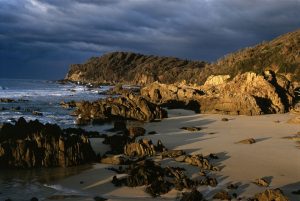
Pictured here is Araganuu at Mimosa Rocks. The National Park describes the rock formations thus “the rocks are middle Devonian volcanic rhyolite and upper Devonian Bunga sandstones. These rocks often demonstrate spectacular large and small scale features such as folds, faults and intrusions. They also form the distinctive features of the castle-like Mimosa Rocks”.
Key access points into the National Park are:
ARAGUNNU & PICNIC POINT . Especially popular picnic and camping areas. Nearest point to the township is Bermagui (to the north).
ARAGUNNU (pictured) is especially well set up for “primitive” camping with basic facilities sensitively integrated into the outstanding natural environment. Facilities include:
Camping Areas
Picnic and BBQ areas (with gas BBQ’s)
Toilets
Rubbish and recycling collection points
Activities include:
Midden Boardwalk (including disabled access)
Beach viewing platform
Beach access
Walking Tracks
Fishing, diving and swimming.
Viewing stunning rock formations
Bithry Inlet
The inlet to Wapengo Lake Bithry Inlet offers a picnic area and access to the sheltered waters of Wapengo Lake.
Middle Beach
Offers a picnic area, walk in camping area (fees apply), access to both lagoon and ocean beaches and a viewing platform. It is a popular surfing spot in NE wind conditions.
Gillards
Picnic area, camping area (fees apply) and access to beach.
Nelson Beach / Wadjurda Point / Moon Bay
Offers carparks and short walking track access to the southern beaches of the park. The area also offers a 500 metre walk along Wajurda Point to a lookout giving magnificent views up the coast. Closest township is Tathra ( to the south).
Camping in the National Park
Further information 02 64 955 000 or 02 44762888
There is a 2 weeks maximum stay in school holidays and 4 weeks at other times of the year.
Camping fees(as at June 2003) are: Nightly fee: $5 per adult , $3 per child 5-15 years
Please note: dogs and domestic pets are prohibited in the park.
Gulaga National Park
Incorporates Mt Dromedary (Gulaga) which dominates the coastal landscape around Tilba, Narooma and Bermagui. The park encompasses an area of 4600 ha. The summit of Gulaga (Mt Dromedary) provides stunning views along the coastline and the park runs down to the shores of Wallaga Lake (and now includes what used to be Wallaga Lake National Park).
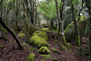
The walk to the top of Gulaga (the Aboriginal name for the mountain) is highly recommended for its attractive variety of scenery and outstanding views. Near the peak is a rainforest with large granite tors interspersed between the trees. The mountain has special significance to the local aboriginal Koori tribe as embodying mother and female aspects and the large boulders (energy rocks) also hold a special meaning to them. Koori guided tours of the mountain are available from Umburra Cultural Centre ( Phone 02 44737169)
Reminders of the early goldmining days are provided by the “Chinamans Grave” half way up the mountain walking track and remnants of a gold mining shaft sunk near the summit. It is suggested to allow 5 hours for a walk to and from the summit however many will do this in 4 hours or less. To get to the walking track, turn up the track besides Pam’s Store in Tilba Tilba.
Gulaga was named by Captain Cook as Mt Dromedary in 1770 when on sighting it from sea he observed its similarity to a camel’s hump.
Website: www.nationalparks.nsw.gov.au
Wallaga Lake National Park
Wallaga Lake National Park is on the eastern side of Wallaga Lake, formed by the drowning of 2 river valleys 6 to 10,000 years ago. It provides a home to more than 200 bird species, including lyrebirds, as well as swamp wallabies, bandicoots and koalas. Merriman Island in Wallaga Lake is gazetted as an Aboriginal Place in recognition of its significance to local Aboriginal people (not accessible to the public and landings are not permitted).
Biamanga National Park
Mumbulla Mountain, located within the Park at the upper reaches of the Murrah River, is sacred to the Yuin people of the south coast. Mumbulla Creek Falls has picnic facilities and barbecues. A boardwalk with wheelchair access leads to a viewing platform over the falls. Access to the Park is 20 km north of Bega off the Princes Highway (unsealed roads).